Category: Uncategorized

  • Getting in Shape for Hiking

    Getting in Shape for Hiking

    As I’m writing this I’m watching the snow slowly melt and summer still seems a long ways off. I’ve been doing what I can to stay fit while juggling the rest of life, but I know now that as the earthy smell of spring fills the air, I’m starting to get anxious to hit the hills.  Hopefully my winter hibernation won’t hinder me for too long. Here are some tips for getting ready to hit the trail this summer

    1.) Give yourself time to prepare. We have very few spring chickens on our trips, myself included. I’m no longer able to pull of backcountry stunts from off the couch and my timeline for preparation is constantly growing. So, know yourself and give yourself plenty of time to get ready, including time for setbacks and distractions. Try to start by going on a brisk walk 2 or 3x week, keeping the pace quick enough to get your heart rate up – then keep your heart pumping for at least 30 minutes. Build from there. And remember if you have some new hiking boots/shoes start wearing them now. As your walks progress you can also wear a light daypack and add weight as you progress.

    2.) Focus on leg strength. It’s pretty obvious that your gams will be feeling most of the burden, but squats are no fun. For those long days on the trail and the day after day you need your dogs to be feeling good. Having strong legs will also help save those old creaky knees on the downhill. Focus on lunges, squats and calf-raises.

    3.) Core Values. Carrying a daypack and sashaying down the trail requires good core strength. It will help you maintain the burden of a backpack as well as keep your balance on any dicey stream crossings or hurdling over down timber. Sit-ups, bridges and forearm planks will get your middle feeling strong. To help with balance practice walking a line on the floor with your arms out or standing on one foot for 30 seconds and then maybe picking something up.

    4.) Don’t forget the practice hikes. Before you head out on your trip try to get in a few practice hikes. Incorporate variable terrain and elevations so you can feel how your body responds and what you may still need to work on. Finish breaking in those boots and make sure they’re going to feel good on your feet. This is also a good time to fine tune your daypack and make sure you have everything you need and that it fits you well and will be comfortable.

    5.) Mental Preparation is important too. Having a good attitude goes a long ways to having a good trip. Think about “why” you are doing this and focus on that when the suffering starts to pop up. Also visualize what success will look like for you.

    6.) Have Fun. Remember you don’t have to be in the best shape of your life to have a memorable and successful adventure.


    — Yve Bardwell


  • Snow Geese Migration through Montana

    Snow Geese Migration through Montana

    Mid March in north central Montana is most often marked by Chinook Winds, melting snowdrifts and the occasional early Douglasia flower. The most spectacular phenomena of all, though, is the annual spring Snow Geese migration. Picture hundreds of thousands of snow geese lifting off from a partially frozen lake: a myriad of flapping wings, honking, and a flying pattern that appears chaotic and completely organized at the same time. It is a sight to behold.

    Freezout Lakes Wildlife Management Area, located between Choteau and Fairfield, Montana, is the epicenter for Snow Geese activity during this time. Montana Fish, Wildlife, and Parks owns and manages the 11,350 acre area.   Over 200 species of birds use Freezout Lake and it is a major resting stop for Snow Geese traveling northbound from California, Texas, and the Gulf Coast. They congregate at Freezeout Lake for a few weeks around mid March before slowly making their way to their nesting grounds – the extreme northwest Arctic coast of Canada and Alaska. The birds generally feed twice a day – they lift off from the lakes in the early morning to go feed in the neighboring grain fields and then return to the lakes in the late morning. This pattern occurs again in the late afternoon. For more information about the geese, check out this flier.

    This year, the community of Choteau is celebrating the migration on March 22 – 24. The event, called Wild Wings in Choteau, includes two free tours of Freezout Lakes with professional birding guides, bird presentations, a showing of the movie “Winged Migration”, and the Old Trail Museum’s Wild Game Feed (a fundraiser for the museum). We will also be offering $5 van rides for folks not wanting to drive their own vehicles during the free tours.


    Schedule of Events:

    Friday, March 22

    7 PM: Winged Migration showing at the Stage Stop Inn.

    Saturday, March 23

    6:30 – 10:30 AM: Guided Tours of Freezout Lakes, the epicenter of Snow Geese activity in the area. FREE. Meet in the lobby of the Stage Stop Inn. Dropstone Outfitting has van space available for $5 or you may take your own vehicle.

    1 PM: White Geese Over Montana. Presentation by Mike Schwitters, world re-known master birder. FREE. Located at the Stage Stop Inn’s Breakfast Room

    5:30 PM: Doors open for the Old Trails Museum’s Wild Game Feed. Museum Fundraiser. Admission is free will donation. Potluck dinner with wild game and non-game dishes, silent auction, live auction, and a 50/50 drawing. Located in the Stage Stop Inn’s Rocky Mountain Convention Center.

    Sunday, March 24

    6:30 – 10:30 AM: Guided Tours of Freezout Lake, the epicenter of Snow Geese activity in the area. FREE. Meet in the lobby of the Stage Stop Inn. Dropstone Outfitting has van space available for $5 or you may take your own vehicle


    Stage Stop Inn Motel Reservations:

    1-406-466-5900 or www.stagestopinn.com.

    Snow Geese Tour Van Reservations: (406) 461-2114 or [email protected]


    Download the Wild Wings Flier


  • Maps on multi-day trips: Tips to help you navigate the Wilds

    Maps on multi-day trips: Tips to help you navigate the Wilds

    Living in an era of digital maps and apps, it is often hard to know what is the best mapping product to use. And if paper maps have become obsolete.

    I wanted to share with you a few map tips that I have learned over the years.

    My first tenet:

    1. Always bring a paper map and know where you are on it. (So of course, no! paper maps are not obsolete!)
    • I am a big fan of using both GPS and paper maps. GPS units are great for pinpointing where you are exactly and navigating in dense trees or confusing terrain, but paper maps give a much better feel of your overall location relative to the surrounding area and relative to your trip as a whole. Paper maps are much easier to see how drainages and mountain ranges fit together.
    • I am also a fan of paper maps because they act as another kind of map – a map of my past, present, and future experiences. They represent places I have been and memories I’ve had, X’s for good campsite locations, and potential route scribbled in pencil in excitement haste. They have stains and small rips from being repeatedly fawned over and used to dream about the next adventure. I am quite fond of them and never leave home without them.
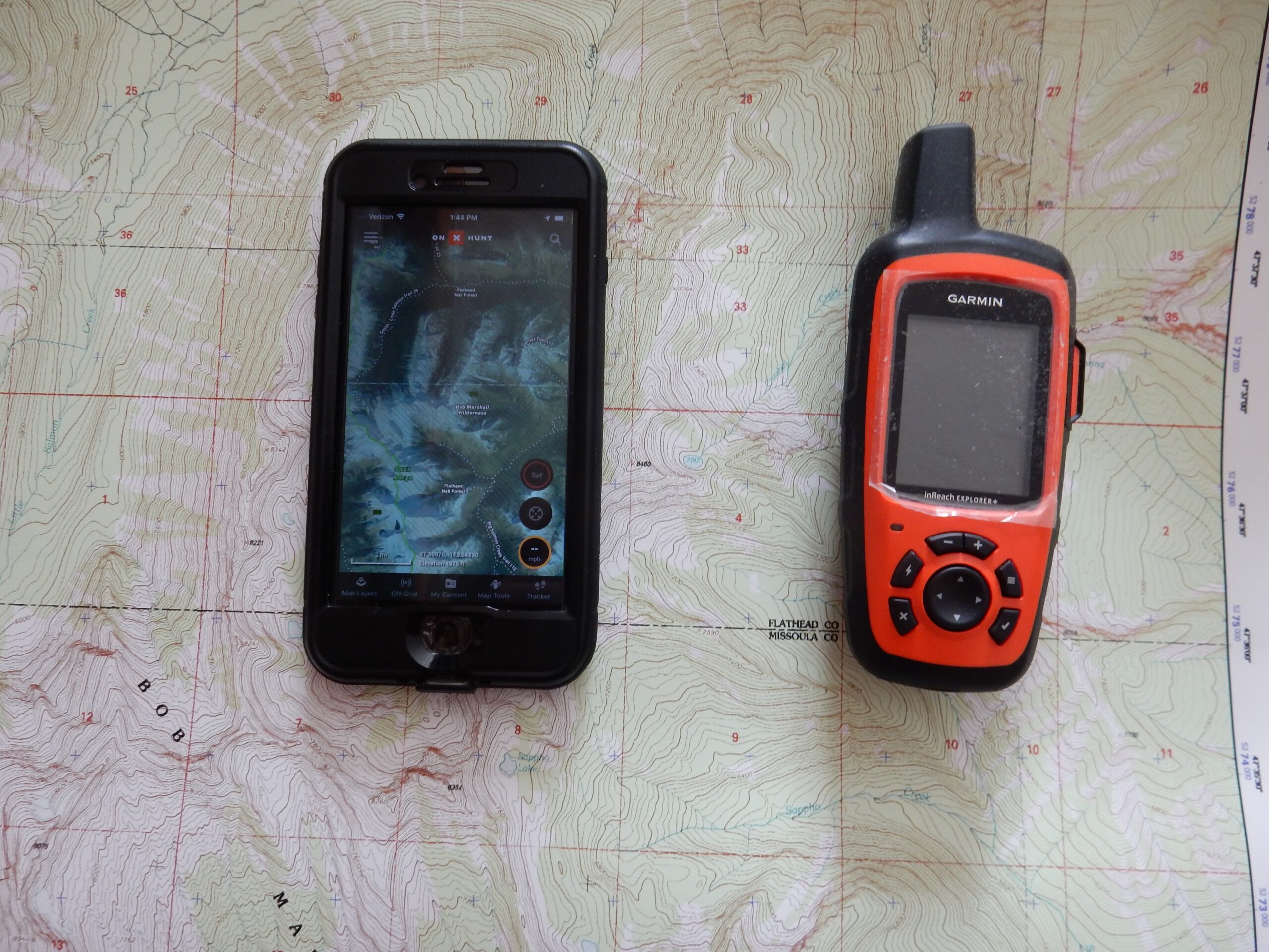
    • What kind of maps do I like to carry? Well, depending on the route and how well I know the terrain (and any time I am doing extensive off trail navigation), I like to use 7.5 minute quadrangles. 7.5 minute quads have a 1:24,000 scale meaning that any measure of the map, if expanding 24,000 times, would match the actual environment. For example, an inch of the map equals 24,000 inches in the field. These maps encompass a relatively small area but show great detail. You can find quad maps at many regional gear stores, Forest Service offices, or maps stores. I also like mytopo.com.
    • I also carry the Cairn Cartographics Maps. They produce, among other things, Bob Marshall Wilderness maps – both north and a south half option. These are excellent topographic maps that show trail miles + they are water resistant + they are from a local company. These are excellent for calculating trail miles, seeing the over all route (particularly when the route covers several 7.5 minute quads), and for naming the mountains I see in the distance. Sometimes, if I know a route quite well, I will just bring the Cairn Maps and leave the quads at home.


    My second Tenet:

    1. The print map and GPS combo is ideal for multi day trips.

    The combo of the GPS, 7.5 minute quad, and the larger scale Bob Marshall map have proved to be the right combo for specific navigation and overall route information. The GPS provides your exact location and helps you navigate in dense trees/confusing terrain, the quad gives you a larger scale view of a relatively small area, and the bigger Bob map is best for orientation and looking at overall route.


    A bit about GPS’s: GPS’s a great because they show you exactly where you are on a particular trail or if you are not on a trail, what you position is relative to where you are going. This exact location marker can be crucial to off trail navigation. You can also track your daily miles and elevation. Or is you are needing to navigate to a point (say a particular campsite), the GPS will help you navigate to that exact point.


    What kind of GPS to Use? There are a lot of them out there, and most of basic models will operate similarly. The bottom line is – there are lots of options and as long as you know how to use it, it will work just fine. We use a Garmin GPSMAPS 64 with the Montana/Idaho maps chip and the Garmin InReach Explorer. The Garmin GPSMAPS 64 (the more basic of the two) is slightly more accurate (as long as you purchase the topo map SD chip for the state you are in) and has better trail and tracking information. And is less expensive because you do not have to purchase an annual plan. However, the Garmin InReach Explorer has satellite texting capabilities. The texting capabilities act just like normal cell phone to cell phone texting (and you can set up Bluetooth so you can use your phone instead of the device). We like this product because it doubles as an emergency communication device.


    BUT, a third option exists. If you do not want to buy a GPS, and you are comfortable taking your phone into the backcountry, there are several apps you can download that function very similarly to a GPS. I have the Gaia GPS and onX Hunt app on my phone, and there are several other companies out there that can do this. The only catch is that you need to download the specific area to your phone before you leave cell coverage so the GPS tracking can function while your phone is off line. Some of the apps are free or have a free basic app level, and those that you pay something for are inexpensive.


    There are apps that will actually download the topographic map to your phone; however, I am still a fan of carrying the paper map in case something happens to the device or the battery runs out and you don’t have a solar charger. Plus, it is easier to orient with a bigger map instead of a small screen.


    I am going to soap box about SCREENS a little. There is something counter intuitive and a bit disturbing about walking down a trail in a beautiful wilderness setting and looking at a screen. One of the reasons to do a backcountry trip is to disconnect from the digital world. Having the GPS on your phone or another GPS is great but does require screen time. I have occasionally gotten myself pulled into the “let’s check the GPS every five minutes” mode, and it really has hampered my ability to disconnect. I like to keep that in mind and only use it when absolutely necessary.


    Some over all navigation pointers:

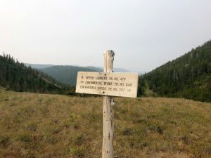
    As you go through an area, periodically check the paper map to orient yourself. Make sure you know where north, south, east, and west are and how the drainages run together. Sidenote – make a habit of occasionally looking behind you. In the event that you need to go back down the trail you just hiked up, it is good to have some familiar landmarks. A trail in the reverse direction can look very different.


    It is a good rule of thumb to always have a backup map incase something happens to the navigation tool you are using – so by having a couple of paper map options plus a GPS, you’ve got your bases covered.


    Learn more about navigation on a Dropstone Trip!

    On a Dropstone trip, we do all of the navigation, but we provide everyone with route maps (courtesy of our friends, Cairn Cartographics), and carry maps for everyone to look at and orient themselves with. We are happy to provide a few pointers in navigation as we travel through the woods. We encourage folks to learn more about navigation because we love maps and because we think it adds to the wilderness experience to really understand where and how we travel through the mountains and valleys of the great big Bob. There’s no better place to learn than along the trail with an experienced Dropstone guide.


  • Tie Hackers in the North Fork of the Sun

    Tie Hackers in the North Fork of the Sun

    by Yve Bardwell


    If you come out on a trip into the North Fork of the Sun, Teton or Dearborn River Drainages you might notice some old, high stumps and wonder what the story is. They pop up into the air 3 feet sometimes 5 and look soft and muted amongst the standing timber. I was told once they were the result of giant beavers.

    But the truth is retold in a great historical piece by John Vollersten about the tie hackers along the Front, featured in the January 2018 issue of the Montana Magazine.

    In 1887 the St.Paul, Minneapolis & Manitoba railroad, owned by James Hill, pushed from the northeast corner of the territory to Great Falls in six months. Ten thousand men and 6,600 horses built that bed by hand and tie-cutting operations along the Rocky Mountain Front provided nearly half a million ties that were cut, hewn and floated from the mountains. Many of those ties came from deep within the Bob Marshall Wilderness.

    In the winter of 1886 (this may ring a bell for many of you as that famous brutal winter that Charlie Russell captured with his sketch of the humped up calf “waiting for a Chinook or last of 5,000) a contract was let to provide the Manitoba line with 600,000 ties to build the line from Great Falls into Canada.


    The work was divided among the drainages, but to me the work done up the Sun River is the most fascinating. In the heart of the Bob Marshall a camp of seventy some men was spiked at the mouth of Headquarters Creek and supplied through the winter with pack stock and burro’s. The men cut on average of 20 trees a day and drug their quarry to the rivers edge to await spring after the trees had been hewn flat with a broad axe on two sides and cut to 8 foot lengths. Teams of oxen would drag the ties to the river and “bank” them.

    The real winter came in February and it is reported that it snowed for 6 weeks with temperatures routinely sitting at 30 – 40 degrees below zero. Some of the hovels these men lived in were no more then that. There are remnants of shacks near Gates Park where men would have crawled through the door on their bellies and not been able to do more then sit-up once they were inside.

    Due to the rugged winter the spring run-off was high and because of some calamities that happened with the ties on the Teton, hackers in the Sun waited until July to unbank their ties and float them down the river. After two months and 121 river miles the ties reached the mouth of the Sun River where they were caught in booms. The banking of ties was reported to have taken place at a rate of ten thousand per day. They were then immediately loaded onto freight trains and sent down the line.


    It was an amazing feat and an even more astounding piece of wilderness history. It is hard to believe when spotting one of these old specters the men and the story behind it. If you’d like to read more you can find a more detailed version of this history in Montana: The Magazine of Western History the January issue. The magazine is available at the Montana Historical Society as well as most newsstands around the state.

  • Getting Ready for Summer Hiking Season

    Getting Ready for Summer Hiking Season

    What are a few tips to get ready for the summer hiking season?

    It’s getting to be that time of year where we all start dreaming of the trails we want to explore and the peaks we want to climb. There’s still snow in the mountains, but the flowers are out, the grass is green, and our summer adventures are just around the corner.

    Besides the plain fact of just getting out there, we wanted to share some of things we do to get ready for the hiking season.

    Check out those boots. See how your boots look after last season – if you need to get new ones, do it soon so you have plenty of time to see if they work or not. I usually like to get a new pair of insoles every season even if my boots are in good condition to make sure my feet are well supported. Also, if the boots are all leather, give them a good oil.

    Get out the daypack. Go through your pack to make sure you have everything you need. A lot of the gear in my pack lives there for the entire summer season so it’s easy to get ready for the next outing. Below is a list of what I carry in my pack when I go out for an all-day hike.

    1. Rain gear – BOTH top and bottom because you never know when afternoon thunder storms will appear
    2. A light pull-over for cool mornings
    3. Small 1st aid kit that has plenty of blister care products
    4. Matches/lighter
    5. A couple of emergency granola bars when your lunch runs out but you still have many miles to go
    6. Hat and gloves – Only need to be light weight. This is particularly necessary for those early summer hikes when the weather might change.
    7. Sunscreen
    8. Pocket knife
    9. Bear Spray
    10. Water bottles or hydration system. We usually take about 64 oz. for a good day in the hills.
    11. Water filtration method if you will be refilling.
    12. Maps – either paper or GPS
    13. And the most important – FOOD! Can’t enjoy a long day hike without it.

    Check that bear spray. If you are hiking in Griz or Black Bear country, you will want to carry bear spray. Make sure it isn’t expired, doesn’t have any dents, and that it still has a safety clip on it. If you have an old can, go out and practice spraying a time or two (be careful of your wind direction!)

    Start getting outside. The best way to get in shape is to go on short hikes or walks several times a week. This will help get your legs in shape for those longer days on the trail. You can even wear your daypack to get used to carrying a little weight and to check that it is properly adjusted.

    Explore your maps. I love starting the season by pouring over my maps and thinking of all the places I want to adventure. Then I think about when would be the best time to go there and who I might like to go there with. A little planning (and dreaming) goes a long way.


    The lower elevation trails are opening up so now is a great time to start hitting the trail!

  • Keeping warm at night in the Bob Marshall Wilderness

    Keeping warm at night in the Bob Marshall Wilderness

    Few moments tick by slower then a long, cold night. Here’s a few tips to keep you warm and toasty on your next camp out.

    Insulate your body against the ground – You lose a lot of heat through conduction. Depending on the time of year or the trip, take two sleeping pads. A foam pad on the ground and your blow-up pad on top of that makes a pretty cushy pad. If you’re traveling lighter, lay down the clothes you’re not using and place your pad on top of that. If you have a ¾ length sleeping pad place your backpack at your feet to keep your legs off the ground.

    Many inflatable pads have differing R-values, so check that out. Another good tip is to re-inflate your pad before you go to sleep. You use hot air during the day to inflate your pad. As the air cools down at night your pad will deflate perhaps leaving you on the ground.

    When choosing a sleeping bag look at the EN number. This is a more accurate representation of what temperatures the bag will keep you warm at. Down bags tend to be warmer and lighter, but are expensive and don’t do as well in wet conditions. Synthetic bags are less expensive and do better in humid environments but are bulkier. You can also bulk up an old bag by adding a liner. During the fall I line my bag with a light 40degree bag and stay pretty comfortable that way.

    Use a hot water bottle or hand warmers in your sleeping bag. These can give off delicious heat at your feet, butt or arm-pits. Hand-warmers often run upto 8 hrs., plus you don’t have to worry about spilling them.

    Keep your head warm. Everyone knows we lose a lot of heat through our heads, but we really do lose a lot of heat through our heads. So keep that puppy bundled and those gaping earholes covered.

    Use your sleeping bag properly. Zip it up, flip the hood over and cinch it down.

    Last but not least….GO PEE. Don’t lay there and think about how cold you will be if you get out of your bag. Your body is spending a lot of energy keeping all that liquid at 98.6 degrees. Just go for it, you’re always glad you do.

  • What kind of hiking boot should I wear in the Bob Marshall Wilderness?

    What kind of hiking boot should I wear in the Bob Marshall Wilderness?

    One of the most important questions (and one that we often get) in hiking is the good old “what kind of hiking boots should I wear?”

    Unfortunately and fortunately, there is not an easy answer to this question. It depends on your preferences and what peculiarities your feet have (all of our feet have ‘em. Could be you have sweaty feet, or long feet, or no arch etc. . . ) We recommend that you find a gear/shoe store that you trust and is good at fitting boots/shoes.

    However, there are a few hiking boot/shoe rules that we adhere to no matter what kind of boot we have. They are:

    1. If you are going to be off-trail, wear a shoe with some ankle protection. I.E., not a low-top hiking shoe.
    2. Wear a new pair of hiking boots for at least 2 months before coming on a trip. Wear them for several days in a row and on uneven terrain. We often find that folks bring shoes that are broken in, but they still get blisters because they A) have not worn shoes several days in a row and/or B) they have not worn shoes on rough terrain to see where the rub spots in the boots are.
    3. If the sole of your boot is starting to come off before the trip, do not bring your shoes on the trip. Sole repair during the trip takes a lot of time, limits your day hiking potential, and is only moderately successful.
    4. Little hot spots are okay as long as they can be managed with the application of duct tape or Leukotape.
    5. Make sure shoes have a sturdy sole
    6. We highly recommend using in-soles like Superfeet or Sole.

    What is the best kind of hiking boot/shoe for you?

    There are several varieties:

    – All-leather, high top boots (often with Gor-Tex).
    • Pros: Great ankle support, perform well on rocky terrain, keep feet drier in rainy/wet environments, usually have a longer lasting life than synthetics
    • Cons: Leather Gor-Tex boots can be very hot. For some folks, this causes additional blister problems. Also leather boots are generally more expensive, and can be heavier than synthetic boots.

    – Synthetic, high top boots (sometimes with Gor-Tex)
    • Pros: Great ankle support, perform well on rocky terrain, if they have Gor-tex they keep feet drier in rainy/wet environments, less expensive then leather boots, generally lighter than leather boots.
    • Cons: Synthetic boots usually do not last as long as leather boots. If they are Gor-Tex lined, they can make feet hot, although usually not as hot as all-leather Gor-tex boots.

    – Leather/Synthetic mix high top boots (sometimes with Gor-Tex)
    • These have a combination of pros/cons of all-leather and all-sythetic boots, but they tend to be lighter than all-leather boots, but not as long lasting.

    – Low-top to mid-top hiking boots
    • These tend to be synthetic or synthetic/leather mixes. If you do not need additional ankle support and don’t tend to roll your ankle easily, many folks like these because they are lighter and typically breathe better. These kinds of boots work well for on-trail hiking, but do not perform well off-trail where more durability and ankle support are needed.

    The big things to keep in mind when buying hiking shoes/boots:

    1. Comfort – do they feel good and are there any rub spots you can feel from the get go?
    2. Structure, durability and stability of shoe
    3. What is your intended purpose for the shoe? On-trail hiking only? A mix of on and off-trail? Scrambling?
    4. What kind of environment is the shoe going to be used in? I.E. wet, dry, cold, hot etc. . .
    5. Price
    6. How long do you want shoe to last?

    We hope this helps you find the right shoe. Remember, you can always bring a shoe home and wear it around your house for a while to decide if they are right for you!